This forum is archived and read only.
Please move to the new forum!
- It is currently 07 Apr 2021, 07:25
Forged Alliance Forever
Forged Alliance Forever Forums
Fastest way of thurning this into a hightmap?
Moderators: FtXCommando, Ze Dogfather
2 posts
• Page 1 of 1
Fastest way of thurning this into a hightmap?
- Attachments
-
- sherwood compressed smallest.gif (3.04 MiB) Viewed 942 times
- Mazahaka
- Posts: 7
- Joined: 11 Oct 2012, 04:23
- Has liked: 0 time
- Been liked: 0 time
- FAF User Name: Mazahaka
Re: Fastest way of thurning this into a hightmap?
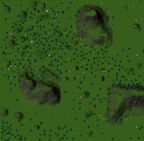
It's virtually impossible to do this in a fast way with the supcom map editor. The map editor imports .raw files for heightmaps and textures. The .raw file has the pixels ranging from 0 to 255 in grayscale. The closer to 255, the higher the corresponding place in the eventual map.
With copying colours from your screenshot you can use photoshop to extract green and turn it into white for areas that you want to be green in the eventual map but you cannot use this for the heightmap. Then all the green bits would be high for example.
With copying colours from your screenshot you can use photoshop to extract green and turn it into white for areas that you want to be green in the eventual map but you cannot use this for the heightmap. Then all the green bits would be high for example.
-

Plasma_Wolf - Supreme Commander
- Posts: 1335
- Joined: 20 Oct 2011, 11:28
- Has liked: 23 times
- Been liked: 91 times
- FAF User Name: Plasma_Wolf
2 posts
• Page 1 of 1
Who is online
Users browsing this forum: No registered users and 1 guest